State Interior Quarantine
A quarantine is established against the following pest, its hosts, and possible carriers:
A. Pest. Red imported fire ant (Solenopsis invicta)
B. Area Under Quarantine. The area under quarantine for red imported fire ant in California is:
1. The entire county of Orange.
2. Los
Angeles County:
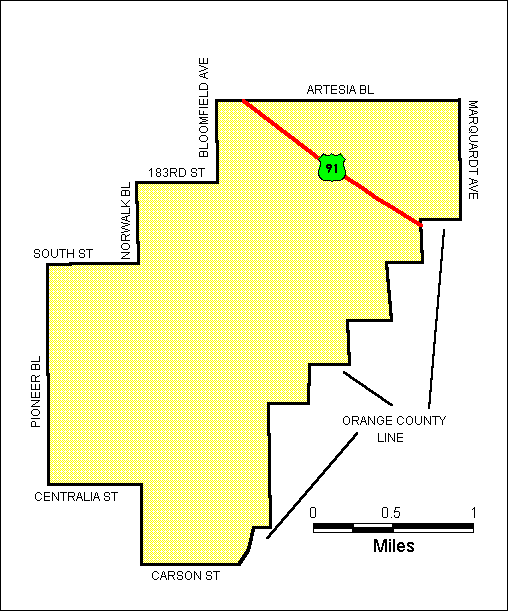
That portion of the county
in the Cerritos area bounded by a line drawn as follows: Beginning
at the intersection of Artesia Boulevard and Marquardt Avenue; then, southerly
along said avenue to its intersection with the Los Angeles-Orange County
Line; then, southerly and westerly along said line to its intersection
with Carson Street; then, westerly along said street to its intersection
with Norwalk Boulevard; then, northerly along said boulevard to its intersection
with Centralia Street; then, westerly along said street to its intersection
with Pioneer Boulevard; then, northerly along said boulevard to its intersection
with South Street; then, easterly along said street to its intersection
with Norwalk Boulevard; then, northerly along said boulevard to its intersection
with 183rd Street; then, easterly along said street to its intersection
with Bloomfield Avenue; then, northerly along said avenue to its intersection
with Artesia Boulevard; then, easterly along said boulevard to the point
of beginning.
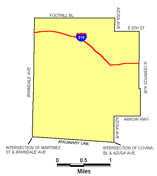
That portion of the county in the Azusa area bounded by a line drawn as follows: Beginning at the intersection of Foothill Boulevard and Irwindale Avenue; then, easterly along said boulevard to its intersection with Azusa Avenue; then, southerly along said avenue to its intersection with East Fifth Street; then easterly along said street to its intersection with North Cerritos Avenue; then, southerly along said avenue to its intersection with Arrow Highway; then, westerly along said highway to its intersection with Azusa Avenue; then southerly along said avenue to its intersection with Covina Boulevard; then, westerly along an imaginary line from said intersection to the intersection of Irwindale Avenue and Martinez Street; then, northerly along said avenue to the point of beginning.
3. Riverside
County:
a.
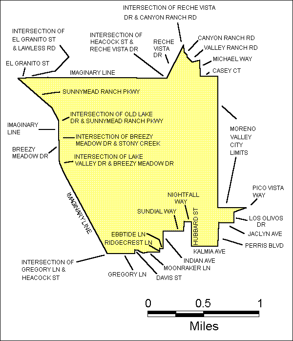
That portion of the county in the Moreno Valley area bounded by
a line drawn as follows: Beginning at the intersection of Reche Vista
Drive and Canyon Ranch Road; then, southeasterly along Canyon Ranch Road
to its intersection with Valley Ranch Road; then, easterly along Valley
Ranch Road to its intersection with Michael Way; then, southerly along
said way to its intersection with Casey Court; then, easterly along said
court to its intersection with the Moreno Valley City Limits; then, southerly
and easterly along said city limits to its intersection with Pico Vista
Way; then, southwesterly along said way to its intersection with Los Olivos
Drive; then, southerly along said drive to its intersection with Jaclyn
Avenue; then, westerly along said avenue to its intersection with Perris
Boulevard; then, southerly along said boulevard to its intersection with
Kalmia Avenue; then, westerly along said avenue to its intersection with
Hubbard Street; then, northerly along said street to its intersection
with Nightfall Way; then, westerly and southerly along said way to its
intersection with Sundial Way; then, westerly along Sundial Way to its
intersection with Indian Avenue; then, southerly along said avenue to
its intersection with Ebbtide Lane; then, westerly along said lane to
its intersection with Ridgecrest Lane; then, southerly along Ridgecrest
Lane to its intersection with Moonraker Lane; then, westerly along Moonraker
Lane to its intersection with Davis Street; then, southerly along said
street to its intersection with Gregory Lane; westerly along said lane
to its intersection with Heacock Street; then, northwesterly from said
intersection along an imaginary line to the intersection of Lake Valley
Drive and Breezy Meadow Drive; then, northwesterly along Breezy Meadow
Drive to its intersection with Stony Creek; then, northeasterly from said
intersection along an imaginary line to the intersection of Old Lake Drive
and Sunnymead Ranch Parkway; then, northwesterly along said parkway to
its intersection with El Granito Street; then, easterly along said street
to its intersection with Lawless Road; then, easterly from said intersection
along an imaginary line to the intersection of Heacock Street and Reche
Vista Drive; then, northerly along said drive to the point of beginning.
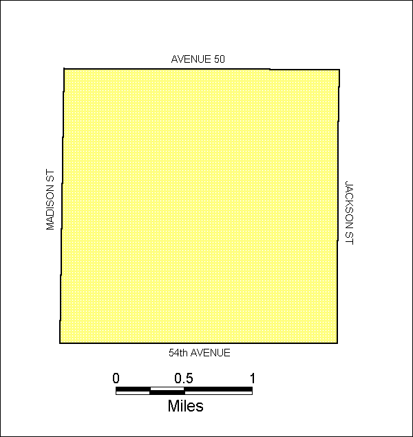
b. That portion of the county in the Indio area bounded by a line drawn as follows: Beginning at the intersection of Avenue 50 and Jackson Street; then, southerly along said street to its intersection with 54th Avenue; then, westerly along said avenue to its intersection with Madison Street; then, northerly along said street to its intersection with Avenue 50; then, easterly along said avenue to the point of beginning.
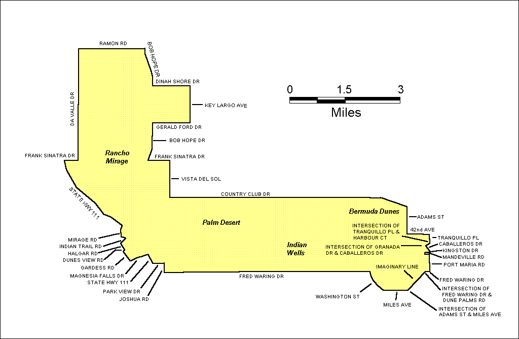
c. That portion of the county in the Rancho Mirage, Palm Desert, and Bermuda Dunes areas bounded by a line drawn as follows: Beginning at the intersection of Ramon Road and Bob Hope Drive; southerly along said drive to its intersection with Dinah Shore Drive; then, easterly along Dinah Shore Drive to its intersection with Key Largo Avenue; then, southerly along said avenue to its intersection with Gerald Ford Drive; then, westerly along said drive to its intersection with Bob Hope Drive; then, southerly along Bob Hope Drive to its intersection with Frank Sinatra Drive; then easterly along Frank Sinatra Drive to its intersection with Vista Del Sol; then, southerly along Vista Del Sol to its intersection with Country Club Drive; then, easterly along said drive to its intersection with Adams Street; then, southerly along said street to its intersection with 42nd Avenue; then, easterly along said avenue to its intersection with Tranquillo Place; then, southerly along said place to its intersection with Harbour Court; then, southwesterly from said intersection along an imaginary line to the intersection of Granada Drive and Caballeros Drive; then, southeasterly along Caballeros Drive to its intersection with Kingston Drive; then, westerly along Kingston Drive to its intersection with Mandeville Road; then, easterly along said road to its intersection with Port Maria Road; then, southerly along Port Maria Road to its intersection with Fred Waring Drive; then, westerly along said drive to its intersection with the Dune Palms Road; then, southwesterly from said intersection along an imaginary line to the intersection of Adams Street and Miles Avenue; then, westerly along said avenue to its intersection with Washington Street; then, northwesterly along said street to its intersection with Fred Waring Drive; then, westerly along said drive to its intersection with Joshua Road; then, northerly along said road to its intersection with Park View Drive; then, westerly along said drive to its intersection with State Highway 111; then, northwesterly along said highway to its intersection with Magnesia Fall Drive; then, westerly along said drive to its intersection with Gardess Road; then, northwesterly along said road to its intersection with Dunes View Road; then, northeasterly along Dunes View Road to its intersection with Halgar Road; then, northwesterly along Halgar Road to its intersection with Indian Trail Road; then, northeasterly along Indian Trail Road to its intersection with Mirage Road; then, northerly along Mirage Road to its intersection with State Highway 111; then, northwesterly along said highway to its intersection with Frank Sinatra Drive; then, easterly along said drive to its intersection with Da Vall Drive; then, northerly along said Da Vall Drive to its intersection with Ramon Road; then, easterly along said road to the point of beginning.
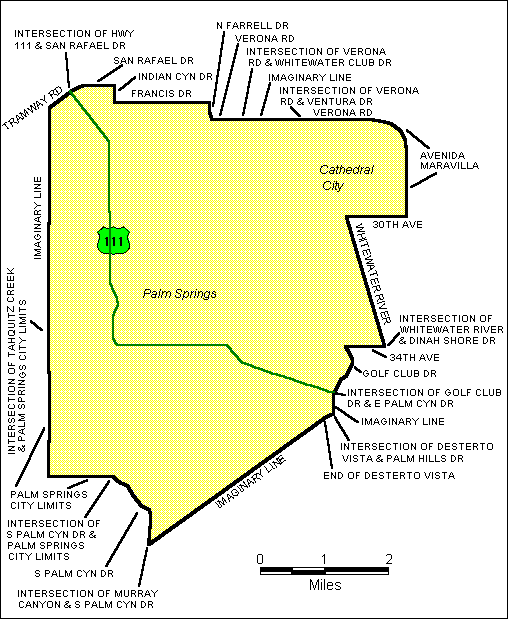
That portion of the county in the Palm Springs area bounded by a line drawn as follows: Beginning at the intersection of State Highway 111 and and San Rafael Drive; then, easterly along said drive to its intersection with Indian Canyon Drive: then, southerly along Indian Canyon Drive to its intersection with Francis Drive; then, easterly along Francis Drive to its intersection with North Farrell Drive; then southerly along North Farrell Drive to its intersection with Verona Road; then, easterly along said road to its intersection with Whitewater Club Drive; then, easterly along an imaginary line from said intersection to the intersection of Verona Road and Ventura Drive; then, easterly along said road to its intersection with Avenida Maravilla; then, easterly and southerly along said avenida to its intersection with 30th Avenue; then, westerly along said avenue to its end; then, due west along an imaginary line from the end of 30th Avenue to its intersection with the Whitewater River; then, southeasterly along said river to its intersection with Dinah Shore Drive; then, westerly from said intersection along an imaginary line to the east end of 34th Avenue; then, westerly along said avenue to its intersection with Golf Club Drive; then, southerly along said drive to its intersection with East Palm Canyon Drive; then, southerly from said intersection along an imaginary line to the intersection of Desterto Vista and Palm Hills Drive; then, southerly along said drive to its end; then, southwesterly along an imaginary line from the end of said drive to the intersection of Murray Canyon and Palm Canyon Drive; then, northwesterly along said drive to its intersection with the Palm Springs City Limits; then westerly and northerly along said city limits to its intersection with Tahquitz Creek; then, due north from said intersection along an imaginary line to its intersection with Tramway Road; then, northeasterly along said road to the point of beginning.
C. Articles and Commodities Covered.
1.Imported fire ant queens and reproducing colonies of imported fire ants.
2. Soil, separately or with other articles, except when commercially packaged. For the purpose of this section, soil shall include all growing media.
3. Baled hay and baled straw stored in direct contact with the ground.
4. Plants and sod with roots and soil attached, except privately owned house plants maintained indoors and not for sale.
5. Used soil-moving equipment, unless free of all noncompacted soil.
6. Any other product, article, or means of conveyance when it is determined by the department or county agricultural commissioner to present a hazard of spreading live red imported fire ant and the person in possession thereof has been so notified.
D. Restriction on Movement, Possession and Sale of Commodities Covered.
1. Movement of Commodities Covered; Commercial Production and Wholesale Distribution. It is unlawful to move within or from the quarantine area a commercial shipment of any commodity covered at the production or wholesale level, except when certified by the department or county agricultural commissioner in accordance with the following provisions:
a. The commodity was treated in a manner approved by the department to eliminate all live red imported fire ant; or,
b.The commodity was inspected and determined to be free from all life stages of the red imported fire ant; or,
c.The commodity has been grown, produced, manufactured, stored, or handled in a manner that would prevent infestation by or destroy all life stages of the imported fire ant; or,
d. The commodity was produced outside the quarantine area and is being transported:
1. through the area by direct route and without delay in closed vehicles or containers to preclude infestation by red imported fire ant; or
2. under permit of the department specifying conditions to preclude infestation by red imported fire ant.
2. Movement of Commodities Covered from Commercial Sources; Retail Level. Retail size purchases of commodities covered obtained from commercial retail sources may be moved into, within or from the quarantine area, if the person in possession has a sales slip or other comparable document showing the purchase was made from a commercial retail establishment. Other transportation of such commodities is prohibited.
3. Movement of Commodities Covered; Not from Commercial Sources.
a.Within the quarantine area, to a specified destination for specified handling, utilization, or processing (the destination and other conditions to be listed in a permit issued by the department or county agricultural commissioner), and this movement will not result in the spread of the imported fire ant, because the imported fire ant will be destroyed by the specified handling, utilization, or processing;
b. Within the quarantine area, no commodity covered shall be moved from the origin premises without a certificate or permit issued by the department or county agricultural commissioner;
c. Commodities covered not obtained from commercial sources may be transported into the quarantine area only if the person in possession has a signed statement showing the commodity, amount, place of origin, destination and date of transportation.
4. Restrictions on Wholesale and Retail Sales. Within the quarantine area, no wholesale or retail establishment shall handle, sell or offer for sale any commodity covered unless such commodities at all times are maintained in a manner approved by the department to preclude infestation by red imported fire ant.
5. No person shall transport,
possess, handle or sell any commodity covered in violation of the provisions
of this section. No person shall knowingly
prepare, possess, or use any false document, or knowingly make any false
statement to any enforcement officer, in connection with the possession,
sale or transportation of any commodity covered.
1999 Maps of Regulated Areas for Red Imported Fire Ant State Interior Quarantine
Orange County: The boundary
lines of the entire county.
Los Angeles County: Cerritos area (see below).
Los Angeles County: Azusa area (see
below).
Riverside County - Four areas: 1. Indio area (see below).
Riverside County: 2. Rancho Mirage
area (see below)
Riverside County: 3. Moreno Valley
area (see below).
Riverside County: 4. Palm Springs
area (see below).